 |
| Not really dressed for hiking... |
I got up somewhat early to go for a run with Natalie, and it was hot and humid. She pushed me to get through six hot, humid, hilly miles. I'm so glad she did! She is a much, much stronger and faster runner than I am, and my goal is to get to a place where she doesn't feel slow as a slug running with me! Thankfully, she never makes me feel like I'm slowing her down, though I can tell I definitely am!
 |
| This was at the top of something... |
After a nice cool shower and breakfast, we decided to go up to the Fells for some hiking. We parked up at Sheepfold and took a look at the Map. We didn't pick a specific trail, just walked through the park (looks like a pretty active dog park) and towards the woods where we saw some trailheads. One of the trailheads was Skyline! I was excited to find it, and we started walking. We didn't bring any water with us this time (unlike at Wachusett) so we weren't going to go too long or too far.
This is the description of "The Fells" from the DCR Website (link above):
Something like five miles northerly from Boston lies a great tract of country, all stony hills and table-lands, almost uninhabited, and of wonderful picturesqueness, and wild rugged beauty.- Sylvester Baxter, Boston Herald Supplement, December 6, 1879
Open year-round, dawn to dusk. The Middlesex Fells Reservation's 2,575 acres offer a welcome retreat for city dwellers and a suitable terrain for hikers, mountain bikers, horseback riders, rock climbers, cross-country skiers and picnickers as well as natural and cultural history buffs. "Fells" is the Saxon word for rocky, hilly tracts of land - an apt name for this scenic area which is rich in local history. This picturesque area was once favored for timber, granite quarrying, ice industry, and water power for the many mills including one that manufactured some of the first vulcanized rubber products. The area was first explored by Governor Winthrop and his men in the winter of 1632: " ...they came to a very great pond, having in the midst an island of about one acre and very thick with trees of pine and beech and the pond had divers small rocks standing up here and there in it, which therefore called Spot Pond." (quote from Gov. Winthrop's private papers)
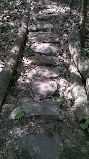
 We started out on Skyline, and I'm glad that we were walking it for the first time. I'd have gotten SO lost! (We did take a few wrong turns... but quickly corrected ourselves.) The paths were anything from rambling over rocks, to dirt paths, to a really cool "rock bridge" (at least I thought it was cool!). See the photo below...
At some point, we switched from the Skyline Trail to the Reservoir Trail, and turned around to come back. It was even hotter than when I ran in the morning, and now very sunny. If we had brought some water with us, we would have likely stayed out there longer. But we're definitely going to be going back! I'm thinking that I may have to take my Camelback out there to do the whole loop soon! (Maybe my next free Friday!)
Here are a couple more photos...
 |
| The Middle (Winchester) Reservoir |
 |
| A smoother part of the path |


No comments:
Post a Comment